INDEPENDENT EXPLORATION GROUP
WEST ASHER PROSPECT - 4 WELL PROSPECT
16775 Addison Rd #305 Addison
TX 75001 469-712-9760

INDEPENDENT EXPLORATION GROUP
WEST ASHER PROSPECT - 4 WELL PROSPECT
16775 Addison Rd #305 Addison TX 75001 469-712-9760
West Asher Prospect Breakdown
4 Oil Wells in Pottawattamie County, Oklahoma
Wells:
Reservoir Targets:
Behind Pipe Formations:
Water Supply Formation:
Project Cost:
Unit Availability:
Reserves:
4 Wells are to be Drilled to 3,800’+/- with 1 Additional Water Supply Well
Calvin / Wannette Sands
Hoover Sand, Hogshooter Limestone, Layton Sand
Pawhuska -1,500 -2,000’
$3,000,000
25 Units @ $120,000 per Unit
3% Working Interest / 2.25% Net Revenue Interest
5,378,880 Barrels of Oil STOIIP - ARM Petro Reserve Report
1,613,664 Barrels of Oil in Reserve – Mid Case Estimate after Waterflood
West Asher Prospect Breakdown
4 Oil Wells in Pottawattamie County, Oklahoma
Wells:
4 Wells are to be Drilled to 3,800’+/- with 1 Additional Water Supply Well
Reservoir Targets:
Calvin / Wannette Sands
Behind Pipe Formations:
Hoover Sand, Hogshooter Limestone, Layton Sand
Water Supply Formation:
Pawhuska -1,500 -2,000’
Project Cost:
$3,000,000
Unit Availability:
25 Units @ $120,000 per Unit
3% Working Interest / 2.25% Net Revenue Interest
Reserves:
5,378,880 Barrels of Oil STOIIP - ARM Petro Reserve Report
1,613,664 Barrels of Oil in Reserve – Mid Case Estimate after Waterflood
Project Details: The West Asher Pool Extension is a 320 Acre vertical development, consisting of a 4 well drilling program with opportunity for addition expansion and secondary recovery via injection wells and waterflooding. This prospect is a southern extension of a field drilled in the 1930’s, the West Asher Pool, with acreage that encompasses portions of section 23 and 26 of Township 6 North, Range 3 East in Pottawatomie County, Oklahoma. The primary target will be the Calvin Sands formation (locally known as the Wannette Sands) at an approximate depth of 3500’-3600’. Secondary targets include the Hoover Sand, Hogshooter Limestone and Layton Sand. The original Calvin / Wannette formation that was the main target locally had wells to the north side of the lease that initially produced between 1,000 and 4,000 barrels of oil per day and had a field accumulation of over 8.5 million barrels of oil, with an engineering report prepared by Ahmed Ragab at ARM Petro estimating an additional 5 million barrels of stock tank oil initially in place, and a mid-level estimate of 1.6 million barrels of oil which would become recoverable with an adequate hydraulic fracturing procedure and from the introduction of hydrostatic pressure via secondary recovery methods such as injection wells and waterflooding.

Development Plan: Drill 4 Wells into the Wannette / Calvin Sands, 2 wells at a time to ensure proper data analysis for in field drilling as a pilot program on the 320-acre West Asher Pool Extension. This lease should encompass the majority if not all of the desired available structure, and additional acreage should not be required. Electrify the field, set up a centralized tank battery for the field equipment, and set new refurbished pumping units on the wells that will run on electric motors. After primary recovery begins, we can assess the 4 existing wells, the production from those wells and proximity to the desired injection locations and convert one of these 4 wells (usually the least productive of the wells) to an injection well to begin to introduce hydrostatic pressure to the reservoir, arresting the decline curve of the producers and theoretically increasing the recovery rate and productive life of the producers significantly. A water supply well will be drilled to the Pawhuska formation, a thick, yet shallow zone that can provide several hundred barrels of water per day, which then can by introduced to the formation via the converted water injector. By injecting water into this reservoir, we should enhance the pressure in the and allow more efficient recovery of the oil that was stranded in place by the original development methods.
Prospect Highlights
The 320-acre West Asher Prospect is located in a southward extension of the prolific West Asher Pool oil field in Pottawatomie County, Oklahoma, a historic field that created an oilfield boomtown in Asher, Oklahoma back in the 1930’s. We believe that this lease was underdeveloped and with proper stimulation, along with a water injection well and waterflood planned for secondary recovery methods, these wells have the potential to make commercially viable quantities of oil and gas.
• The West Asher Pool has a substantial history of production, and the local area had very few true dry holes, especially on structure. Wells to the north were drilled primarily in the 1930’s and often had high pressure and initial flow rates between 1,000 and 4,000 barrels of oil per day.
• These wells typically had high gravity oil (42), very low initial water production, and were able to flow under their own pressure despite the use of 1930’s era drilling technology.
• The Wannette Sands are a lithological stratigraphic trap in this area and there are a significant number of wells within the general vicinity of the field extension that exploit this zone. The field itself is a direct southern extension of the original West Asher Pool directly connected to the north portion of this prospect’s lease.
• Wells produced in this area were often able to show substantial results with now outdated technology and more often than not came on flowing at a high rate of production. Many local wells were not fracked or had only small stimulation procedures performed on them and still were able to produce significant results. It is believed that the proposed new locations to the south of the original field may still have strong production potential, and fracking these wells may aid in recovery.
• The field’s original source of energy was expended in lease to the north, which may have led to the southern portion of the field potentially having very large reserves stranded in place due to the release of pressure when the original field was drilled in the 1930’s. This is the type of field that typically benefits from adding injection wells and waterflooding, and our geologist and 2 consulting engineers believe that this field would benefit from these secondary recovery methods.
• A local field on a similarly structured reservoir with 3 producers and one injection well was able to increase production on its older producing legacy wells from 3 barrels of oil per day to 50 barrels of oil per day after the introduction of 200,000 barrels of water to the Wannette Sand.
• The proposed secondary recovery tactics are an efficient way to not only maintain reservoir pressure and displace oil toward the proposed wellbores, but also is able to dramatically slow the decline in production that wells experience, often allowing wells that would otherwise deplete on a much quicker scale to produce more oil for much longer. Secondary recovery efforts such as adding injectors and then waterflooding can allow a field to produce for decades, even after primary oil recovery has been depleted or wells have been deemed non-commercial.
• Wells should contain more than one pay-zone apiece, giving us multiple shots at achieving commercial production, possibly extending the life of each well considerably.
• With this information considered, we believe that we should be able to achieve an initial target production of 30 barrels of oil a day, per well. This should be sufficient to allow a quick return on investment and a long-term revenue stream of between 25% and 50% per year at $70 oil.
• The Tighlman #1, down-dip to the southwest of our lease, appears to be benefitting from a water disposal a mile away. This well’s production has been increasing steadily over the last 33 years!
Prospect Economics
1 Unit = $120,000 3% Working Interest / 2.25%
Net Revenue Interest
The reserve study's findings highlight substantial potential for expanding this pool through the drilling of up to five new wells at 40 acre spacing, coupled with the utilization of hydraulic fracturing to enhance well productivity and optimize oil recovery. Furthermore, an examination of waterflooding as a secondary recovery mechanism indicates promising prospects for augmenting oil recovery. To formulate the most effective development plan and anticipate oil recovery, an analysis of the production performance of the West Asher field and comparable analogs in proximity was conducted. The table below succinctly presents the volumes of STOIIP (Stock tank oil initially in place) and reserves for both primary and secondary development phases.
TABLE 1: STOIIP AND RESERVES SUMMARY OF CALVIN SAND - WEST ASHER POOL EXTENSION - EFFECTIVE 1 FEBRUARY 2024

With this reserve study considered, we believe that it is a reasonable conclusion that the field development plan could conservatively net approximately 50,000 barrels of oil, per well, in primary recovery, and net an additional 100,000 barrels of oil as we enhance the production through the proposed secondary recovery methods. The injection of water from a water supply well into the Wannette is an excellent way to maintain formation pressure and reduce declines in production. This should keep production near initial levels for as long as the stock tank oil in place is able to continue to be driven to the producing wellbores. With all of these factors considered, our engineers are of the opinion that this field could have a productive lifespan of 50 years if successful.
Gross Cumulative Economic Projections at $70 Oil
Based on the engineering report, we are estimating that 50,000 barrels per well in primary recovery and an additional 100,000 barrels of oil in secondary recovery would be a reasonable estimate of the cumulative production from this field. The plan is to eventually convert one of the producers into an injector if suitable older wells are not available to re-enter and convert. For this reason, we will include only 3 producers in these projections, which also assume an average oil price of $70. The goal is to develop this field and establish a long-term annual net ROI of between 25% and 50% at a $70 barrel average, with the waterflood slowing the decline curve dramatically or even enhancing production significantly to much higher levels and allowing this revenue stream to last for decades.

West Asher Pool Extension Geology
1 Unit = $120,000 3% Working Interest / 2.25%
Net Revenue Interest
The West Asher Pool Extension is a southward expansion of the historic West Asher Pool in southern Pottawatomie County, Oklahoma, residing between the old 1930’s boomtowns of Asher, Oklahoma and Wannette, Oklahoma. This area is a part of the Central Oklahoma Uplift which continues to be a highly prolific oil producing region to this day. The topography of the study area is characterized by low, rolling hills, which is typical of south-central Oklahoma. Widespread deposition of the Arbuckle limestone indicates the presence of a deep, extensive sea during the Cambro-Ordovician era, coupled with a period of intense erosion following the deposition and uplift of the Hunton group. Locally the entire Hunton group and part of the Sylvan shale were removed due to this erosion, however Pennsylvania deposition was essentially uninterrupted. Desmoinesian sediments were deposited within overlapping seas upon many of these structures. Minor faulting, most likely associated with structural rejuvenation, is evident through sediments as young as the lower Missourian.
The West Asher Pool consists of all or portions of sections 13, 14, 22, 23, and 26 of Township 6 North, Range 3 East, with facies changes and wedging-out of the Layton and Wanette sands causing the entrapment of significant reserves of oil within the entirety of the West Asher Pool. The area appears to be bound by a fault to the north and truncation of the Wannette / Calvin sand to the south and east. The Wannette sand formation is characterized as a porous, permeable sandstone with a maximum net thickness of 40’ and an average of approximately 10-20’ thick. The reservoir's location, structure, and isopach maps are included.

The main target formation, the Wannette Sand, (a localized name given to the lower Calvin Sands) lies at a drilling depth of 3,400’-3,600’ and is the basal sand of the Pennsylvanian system which lies just above the regional Pre-Penn unconformity. In this area the Woodford shale is roughly 200’ thick and lies directly below the unconformity, acting as a primary source rock for oil in this portion of Oklahoma. The close proximity of these sands to the Woodford shale enables stratigraphic and structural traps within the Calvin Sand interval to be incredibly prolific producers. The Wanette Sandstone formation consists of fine to medium grained, calcareous sandstones, separated by dark-gray fossiliferous shales. Updip changes in facies and lateral wedging out of these sandstone units are responsible for the productive accumulations of oil in the West Asher pool area. These Calvin sands range in porosity from 10% to 25% with good permeabilities in the productive areas. These factors lead to these sands having high initial oil recoveries along with strong responses to secondary recovery methods such as waterflooding.
The West Asher Pool extension that makes up this prospect lies on a structural trend with the original West Asher Field which was discovered in 1930 and borders this 320-acre prospect to the north. This formation averages 10-20’ thickness throughout the prospect with an estimated average of 20% porosity throughout the 320-acre extension. Rapid infill drilling in the 1930’s led to incredibly high pressure, high production wells capable of initial production from 1,000-4,000 barrels of oil per day with little water. The original development in the northern portion of the structure used up much of the initial energy that this field exhibited, leading to a decline in the initial production of wells as they made their way south, developing the structure. Wells drilled at later dates on this structure often had lower initial production numbers as the natural solution gas pressure was expended, and often times these wells were shut in once they slowed to between 1 and 4 barrels of oil per day in favor of drilling new producers.
Exploration History
The town of Asher, Oklahoma, like many of the other local boomtowns, sprang up almost overnight with the discovery of oil in the area in 1927 with the discovery of the Pearson well and high-pressure oil structures in and around the town. Within a very short period of time, oil executives, oilfield workers and the supporting doctors, restaurants, feed stores, and other boomtown era infrastructure moved into the town, creating a booming oilfield economy in Asher. In August of 1930, the West Asher Pool was discovered by drilling a wildcat well in August of 1930, with oil encountered at a depth of 3515’. Within the next year, more than 50 oil wells were drilled, and the initial production from many of these early wells in the West Asher Pool fell between 1,000 and 4,000 barrels of 42 gravity oil per day. Cumulative production from this field is over 8,500,000 barrels of oil to date from primarily the north pool.
In 1961 a small water-flood program was initiated by Cities Service in the north portion of the pool, but due to what we understand to be apparent legal issues with inheritance rights, was soon afterwards sold to a plugger who eventually pulled the casing from most of the injectors and shut down the water supply well. This zone was never actually waterflooded as planned and most of the infill wells were plugged despite still producing oil. Some examples of this are the RE Tomlin #7, which IP’d in 1930 at 2,335 barrels of oil per day and was plugged while still making 3 bopd of oil per day, and the D. Alexander #1, which IP’d in 1930 at 165 barrels of oil per day and was plugged despite still producing 4 barrels of oil per day. The wells in this era typically weren’t stimulated and yet were able to come on flowing with tremendous volume until the bottom hole pressure gave out, at which point most were plugged. Wells that were allowed to produce at lower volumes within this field often were able to produce for decades, with many of these lasting over 50 years, and some still active to this day.
The 320-acre prospect is a direct southward extension of this original West Asher Pool on adjacent property, and we have reason to believe that it encompasses some of the best characteristics of this Wannette structure, residing up-dip from other notable producers with an average estimated porosity of 20%, good permeability and 10-20’ thick reservoirs. The field also benefits from our ability to capture oil in the primary recovery stage since this extension of the original field was not over drilled like the original northern portion of the field. To the southwest of the extension on a 40-acre lease, a single well, the Tighlman #1, was drilled and completed in 1991 in the common target pool Wannette Sand. This well lies approximately 100’ down-dip to the 320-acre prospect and yet has recovered nearly 70,000 barrels of oil from when reported production started in 1998 to present. This well not only has been highly productive over the 33 years since it was drilled but has also achieved a steady production increase over the last decade, a highly unusual occurrence for a well with no water injection nearby. The Tighlman #1 is possibly benefitting from a saltwater disposal located approximately a mile to the north of the well, with our drilling prospect located directly in between this well and the disposal that has been potentially adding some hydrostatic energy to the Wannette Sand. This, theoretically, would be the reason that production in the Tighlman #1 has been slowly increasing over the last decade, with it still making about 16-17 barrels of oil per day and selling several loads of oil per month consistently decades after it was drilled and first produced.
By securing the acreage directly in the path of this potentially introduced hydrostatic pressure, and drilling wells in a thick portion of this the West Asher Pool’s underdeveloped southern extension, we believe that it is reasonable to assume that we can obtain, if the engineers and geologist are correct, projected initial production of 30 barrels of oil per day, per wellbore, along with potential for a successful waterflood program to arrest decline and allow secondary recovery to begin.
Development Plan
The Initial development phase will consist of 4 new oil wells drilled in strategic 40 acre spaced locations in the southern extension of the historic West Asher Pool in Pottawattamie County Oklahoma. These new wells will be drilled in a manner which passes through multiple hydrocarbon bearing reservoirs before ultimately reaching the target reservoir, the Wannette Sand, at approximately 3,500’-3,600’ deep, then fracture stimulating with slickwater or crosslink and a proposed 40,000 lbs. of sand proppant. We will also drill a shallow water supply well in the Pawhuska and eventually convert the least productive of our wells into an injection well to stimulate the field through waterflooding. If all four oil wells achieve a high level of production, an optional fifth well may be drilled if the partnership desires to expend additional capital on preserving the fourth producer, instead of converting to an injector.
This field has sufficient porosity and permeability for injection wells to provide the additional energy required to effectively drain the field. When the reservoir pressure declines to a point that beginning secondary recovery via waterflood becomes attractive, one of the producers may be re-entered and converted into an injection well. This should arrest any decline in production and may additionally bring hydrocarbon production back to initial levels. Optimally, once waterflooding has introduced several hundred thousand barrels of additional water and hydrostatic pressure to the reservoir, production rates could be raised significantly higher and may even exceed the rate encountered when the wells were first drilled. Several old, plugged wellbores that exist within the field may be candidates to be re-entered and ultimately be repurposed as additional water supply wells or injection wells. This can be accomplished by drilling out the cement plugs, circulating the heavy mud used to plug the wells to the surface and testing the integrity of the existing casing. Additionally, many of these wells were plugged still producing small quantities of oil, which may present an opportunity to apply modern stimulation, pumping techniques and injection protocols. This was already done with the Farley #1, drilled in 1930 with initial production of 155 barrels on day one, and 190 barrels of oil on day 2, and then plugged years later still producing about .5 barrels of oil per day. This well was re-entered in 1961 and the well’s completion records filed with the Ok. Corporation Commission state that it was able to produce 15 barrels of oil, pumping, in the 3 hours it was tested following being stimulated and put on pump. Many of these older wells were plugged still producing 1-4 barrels of oil per day per records filed with the OCC.

Water supply wells are to be drilled or can be repurposed from past plugged wells without significant expense, and the cost of which is included in the proposed budget. The Pawhuska formation has compatible water at a depth of approximately 1500’ – 2000’ and can be air-drilled, limiting expense. Benson Operating, the operating entity, also owns a water transport and may assist in water supply when the unit is available to save some expense.
This prospect is defined by an extensive amount of historic well data, raster logs, scout card records, data provided by the Cities Service to the Oklahoma Corporation Commission, scanned historical completion records, geological mapping and cross-sections, and geological comparisons. The large reserves still stranded in place, coupled with the original 1930’s drilling conditions, unexplored locations within the extension, low water saturation, high porosity and permeability, high oil gravity, and successful local responses to waterflooding in similar structures leads our team to believe that this 320 acre extension of the West Asher Pool should have good initial production and have an ideal response to the addition of injection wells and waterflooding the field.
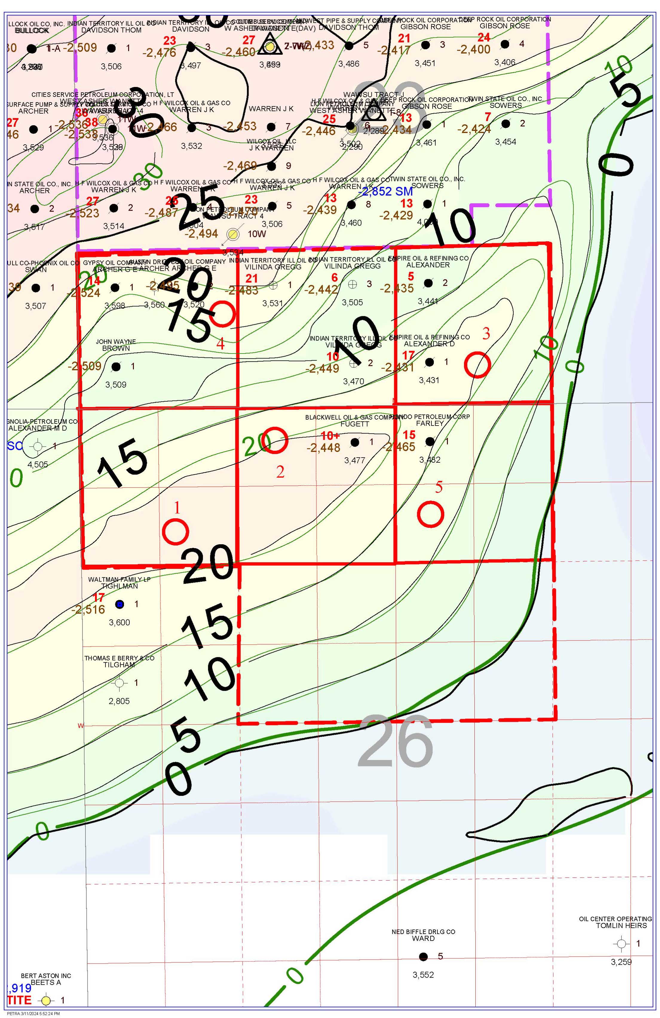
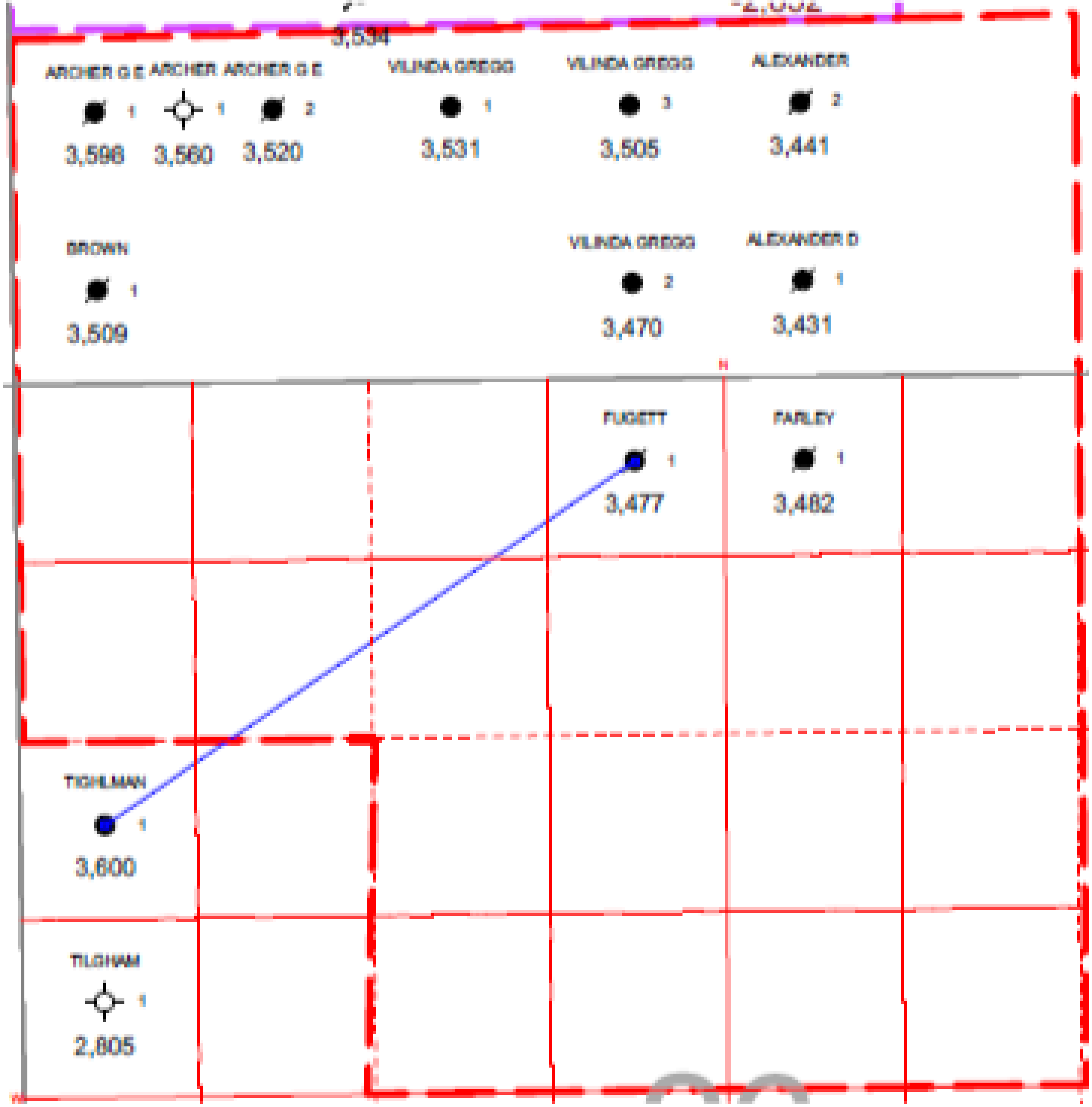
Lease Structure Map, Prior Wells, and Proposed Drilling Locations
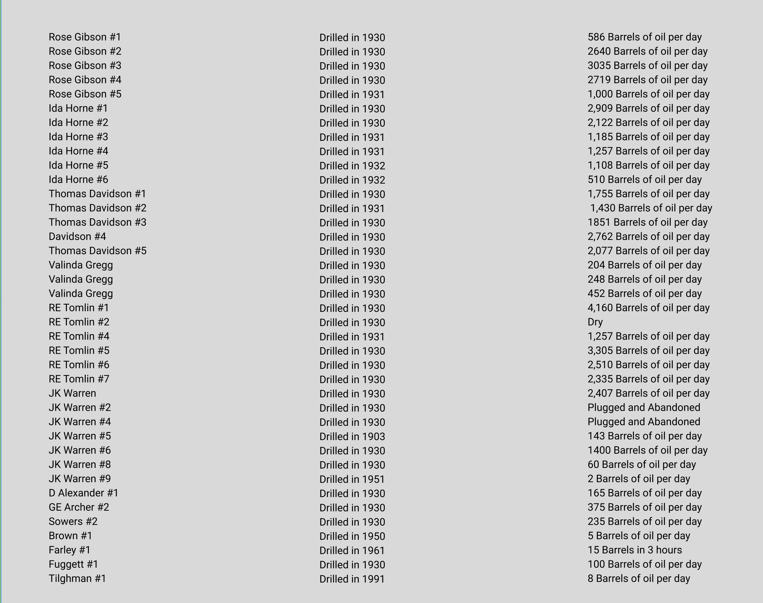
Historic Wells in Target Formation (Wannette Sand)
Within 1 Mile of West Asher Prospect Lease Acreage
Wells reside within the 320-acre prospect and the directly to the north in section 23 6N 3E
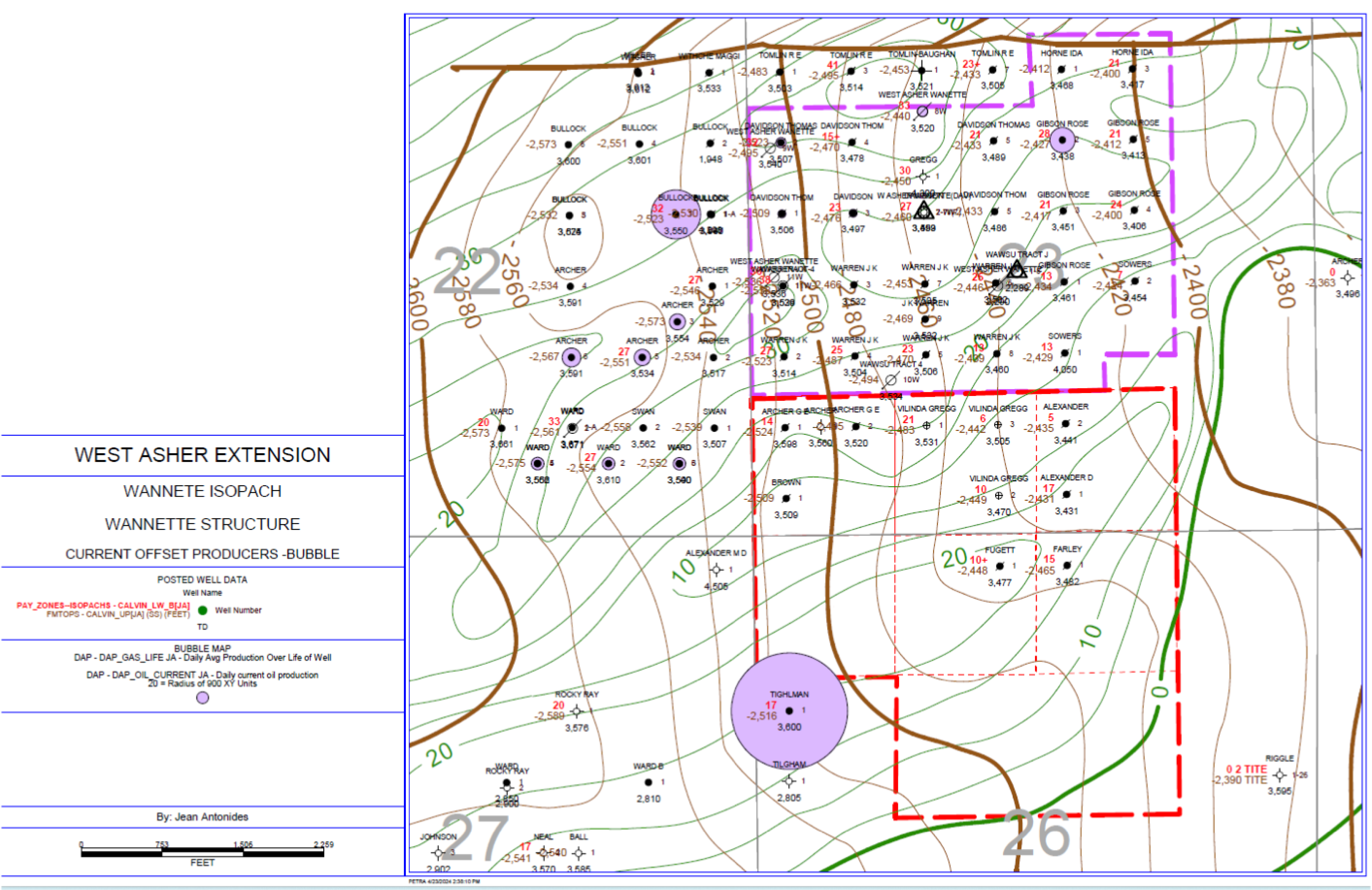
West Asher Pool Isopach Map and Off-Set Producers
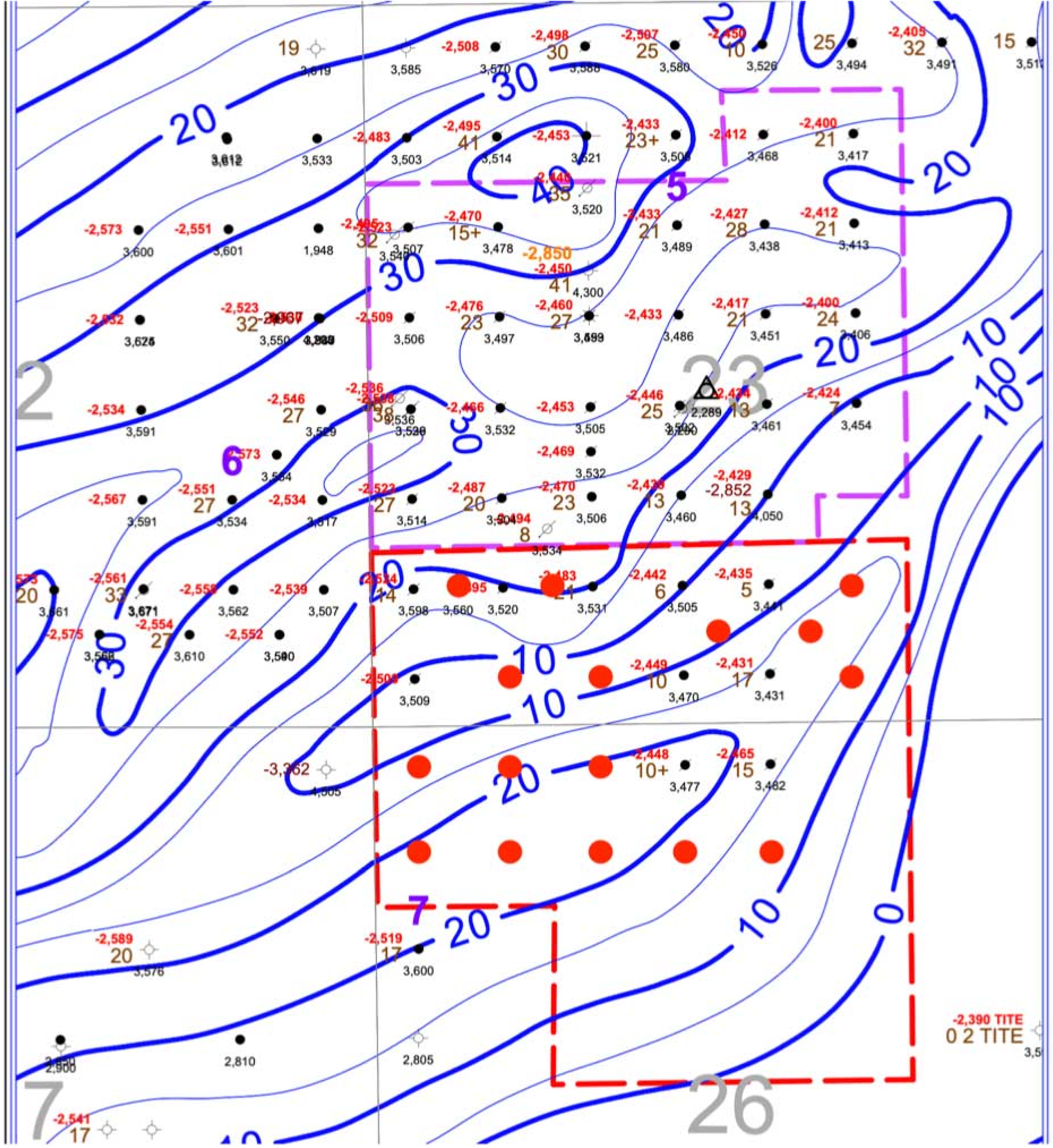
This map is able to demonstrate the lease outline, comparative structure thickness, Wannette reservoir depths, locations of previously drilled local wells and active producers, location of the existing active salt water disposal to the north (the active SWD is the northmost triangle, we believe the other is currently inactive). The Wannette was drilled heavily in the 1930’s, and some of these legacy wells are still active to this day, still productive almost 94 years later. The field was developed at 10-acre spacing to the north; however, the southern extension was left underdeveloped, leaving us with attractive opportunities to drill new wells at 40 acre spacing. This map should also clearly illustrate the proximity of our lease to the original 1930’s wells, our mostly up-dip position on the anticline structure, and the reason we believe that drilling between the down-dip Tilghman #1 and the original West Asher Pool to the north as an extension of the original field could prove lucrative.
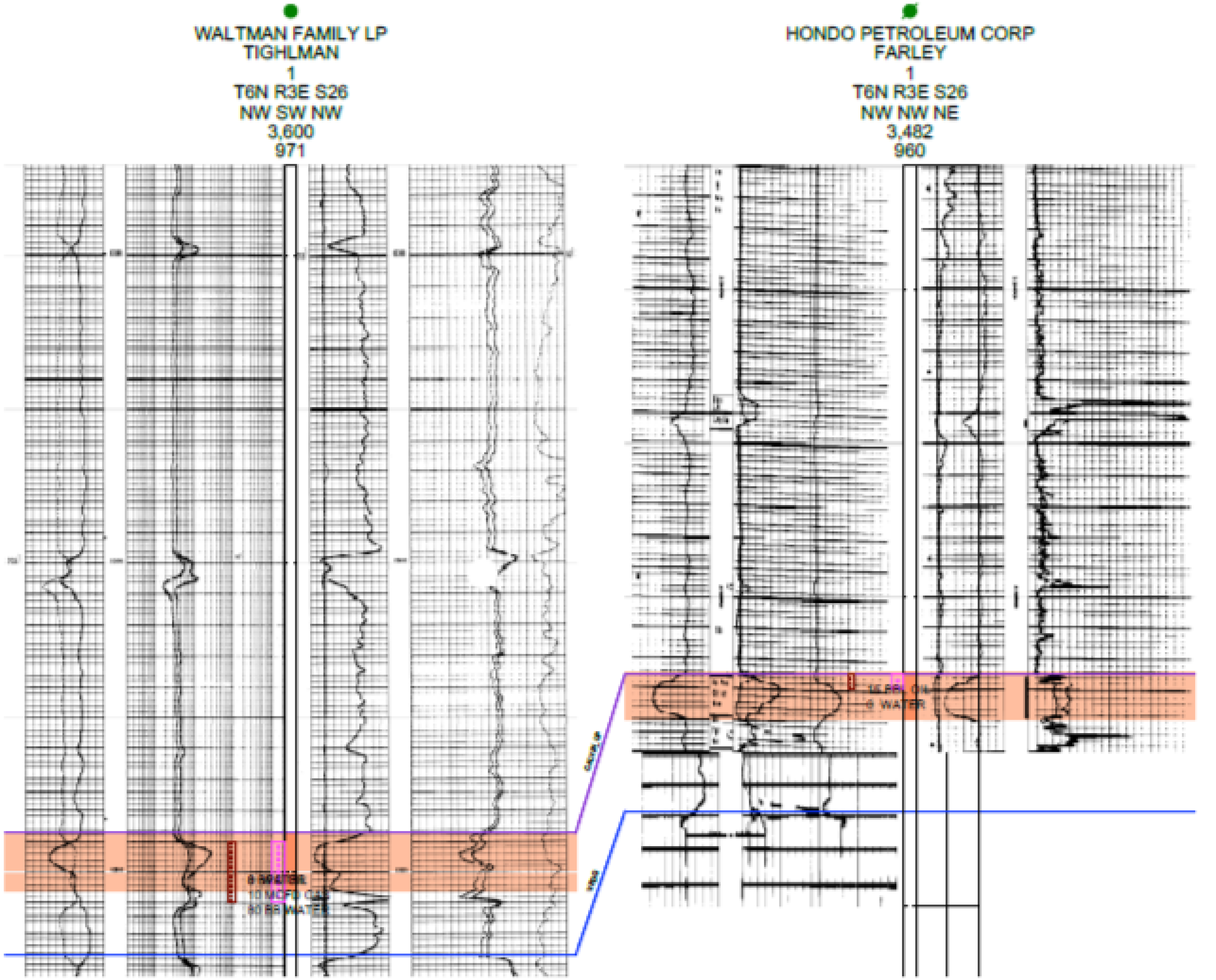
Log Cross Section
The majority of the 320-acre lease is believed to reside on the top of the structure, in an up-dip position. The producer to the south is in a down-dip location from this prospect and has still proven to be highly productive. The best example well from within our lease, Farley #1, shows a reservoir depth of 3,482’ compared to the Tilghman #1 at 3,600’. This shows that the lease is potentially on some of best part of the structure, being almost 120’ up-dip from a well that has produced almost 70,000 barrels of oil to date.
Tax Advantages of Oil and Gas Investing
As a general partner participant, each partner benefits from the tax deductions available for oil and gas drilling including intangible drilling costs, depreciation, operating costs, and percentage depletion. Structured properly, partners may offset their taxable income gained from other sources with the substantial deductions available from investing in oil/gas wells.
Intangible Drilling Costs
Intangible Drilling Costs (IDCs) are drilling expenditures related to expenses such as labor, chemical, hauling, etc. IDCs usually represent 70% to 85% of the cost of a well and are eligible for the election to be deducted 100% against taxable income in the first year. For example, investing $50,000 in a project that had 85% of its costs in IDCs would mean the investor can deduct $42,500 from their taxable income for that year. In a top 39.6% federal tax bracket for individuals, that deduction would save approximately $14,875 in federal income taxes for that tax year. To encourage expenditures for oil and gas drilling, IRS code section 461 has a special provision that allows IDCs paid before 12/31 of any given tax year to still be deducted in the same tax year provided the drilling of the well commences before the close of the 90th day after the close of the taxable year and other certain conditions are met as per the regulations.
Tangible Drilling Costs
The costs of oil and gas drilling equipment such as casing, pumping units, tanks and wellheads are Tangible Drilling Costs (TDCs). Continuing with the example above, the remaining $7,500 (15% of the cost of the well) would be TDCs. These costs are capitalized and depreciated over a period of seven years.
Depletion Deductions
When a producing well is drilled, the partner can recover the capitalization cost of the oil and gas property through depletion deductions. There are two ways to calculate the allowable depletion deduction: the cost depletion method and the percentage depletion method – and the taxpayer may take a deduction for the greater of the two. Cost depletion is computed on the basis of initial capitalization cost. Over the life of the well, a portion of these costs can be recovered each year based on the percentage of the production for the year as compared to the estimated recoverable oil and gas reserves at the beginning of the year. Percentage depletion is computed on the basis of the income from the property rather than capitalization costs. The tax shelter provided by percentage depletion may result in larger deductions than cost depletion. Percentage depletion allows a tax deduction equal to 15% of the gross revenue from an oil and gas producing property. This deduction is limited to 100% of the net income of the property. Also called the “Small Producers Exemption”, this provision is generally only available to independent producers and royalty owners. Percentage depletion applies to producing oil and gas wells with average daily production less than 1,000 barrels of oil or 6,000,000 cubic feet of gas. The tax shelter provided by the percentage depletion allowance endures for as long as the well produces.

Drilling Program Reserve Report

PREPARED BY
AHMED RAGAB
INDEPENDENT PETROLEUM ENGINEERING CONSULTANT
January 2024
ARM is acting in an advisory capacity only and, to the fullest extent permitted by law, disclaims all liability for actions or losses derived from any actual or purported reliance on this document (or any other statements or opinions of ARM) by 1 Columnthe Client or any other person or entity.
EXECUTIVE SUMMARY
The primary aim of this investigation is to assess the expansion of the West Asher Pool, involving the implementation of a five-well drilling initiative. The targeted acreage spans sections 23 and 26 within Township 6 North, Range 3 East, situated in Pottawatomie County, Oklahoma. The key focus will be on the Calvin formation, situated at an approximate depth of 3600 FT. Additional objectives encompass the Hoover Sand, Hogshooter Limestone, and Layton Sand as secondary targets.
The study's findings highlight a substantial potential for expanding this pool through the drilling of five new wells, coupled with the utilization of hydraulic fracturing to enhance well productivity and optimize oil recovery. Furthermore, an examination of waterflooding as a secondary recovery mechanism indicates promising prospects for augmenting oil recovery.
To formulate the most effective development plan and anticipate oil recovery, an analysis of the production performance of the West Asher field and comparable analogs in proximity was conducted. Table 1 succinctly presents the volumes of STOIIP and reserves for both primary and secondary development phases.

TABLE 1: STOIIP AND RESERVES SUMMARY OF CALVIN SAND - WEST ASHER POOL EXTENSION - EFFECTIVE 1 FEBRUARY 2024

The project's overall economics were run for the Mid-Case of both development phases. Table 2 summarizes the economic results for the most likely case of the production forecast (Mid-Case) at different oil prices. The economic results confirm the project's viability.
TABLE 2: Summary of the results of the economics

EXECUTIVE SUMMARY

Based on the available data from the West Asher field and the analog fields. The reservoir data is summarized in Table 3. The Calvin formation is characterized as a porous, permeable sandstone with a maximum net thickness of 40 ft with an average of approximately 20 ft. The formation is of sufficient reservoir thickness and continuity throughout the study area. It contains light oil (42 °API).
TABLE 2: Summary of the results of the economics
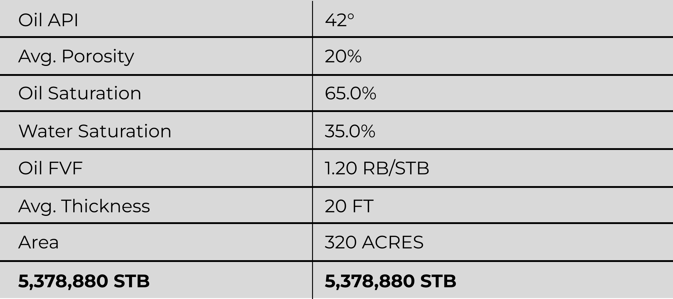
The reserves are calculated from decline curve analysis based on the available production data and in light of the offset fields' performance. The recovery factor of depletion drive reservoirs ranges from 10% to 25%. Assuming the recovery factors for West Asher Pool are in the range of 10% for the low-case, 15% for the mid-case, and 20% for the high-case. Table 4 summarizes the most likely reserves for the total pool acreage, and Table 5 summarizes the most likely reserves for a typical well in the Pool.
TABLE 4: Summary of Oil Reserves

TABLE 5: Summary of Oil Reserves Per Well

PRODUCTION FORECASTING
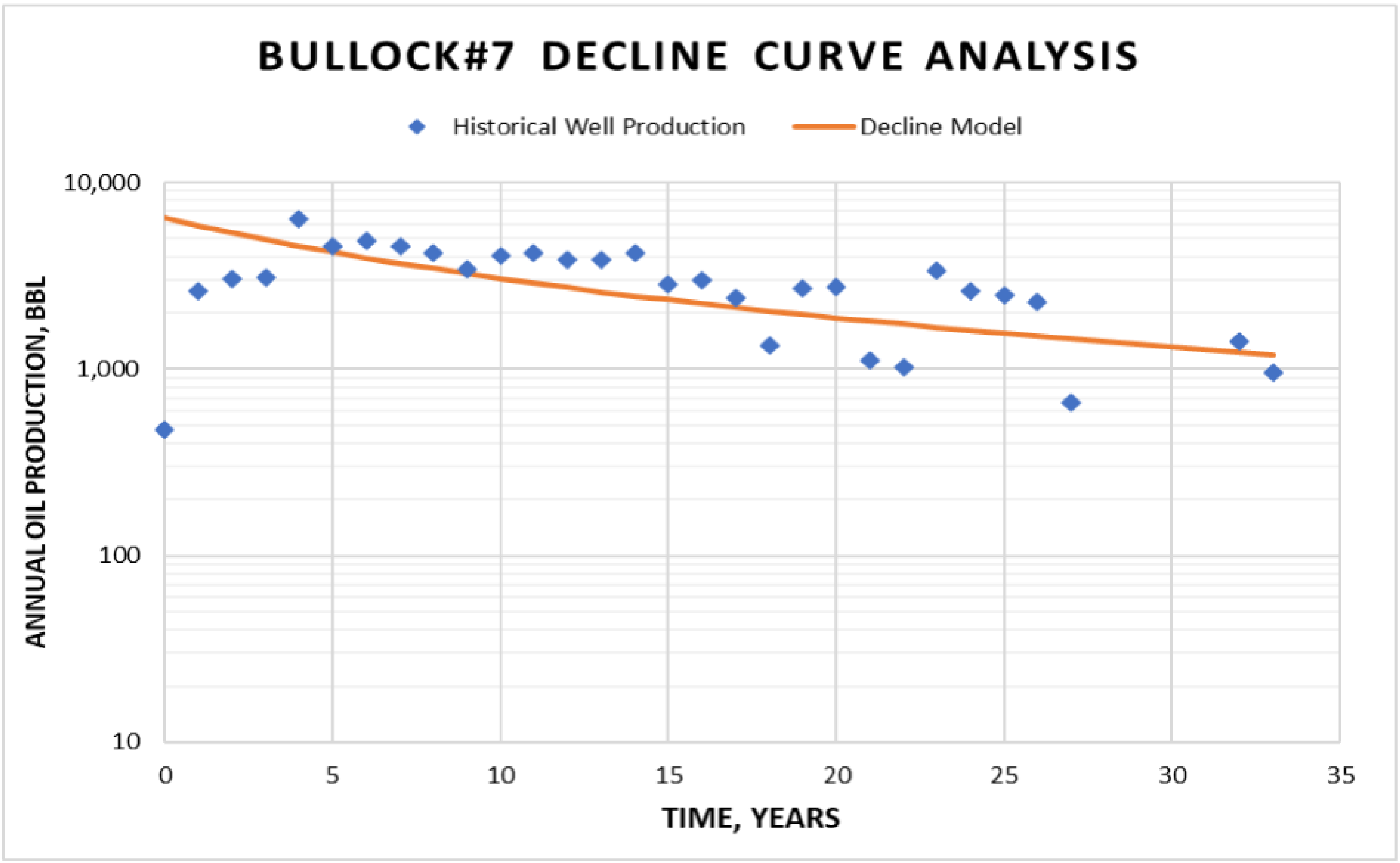
The current offset wells are producing at an average oil rate of 12 bbl/day. The decline curve analysis for Tighlman#1 and Bullock#7 well is shown in Figure 1 and Figure 2, respectively. Tighlman#1 shows no depletion or production decline, which indicates the wells are connected with significantly large volumes of oil; more wells are required to drain these volumes. On the other hand, Bullock#7 shows a gentle decline trend.

Figure 1: Tighlman#1 Historical Oil Production
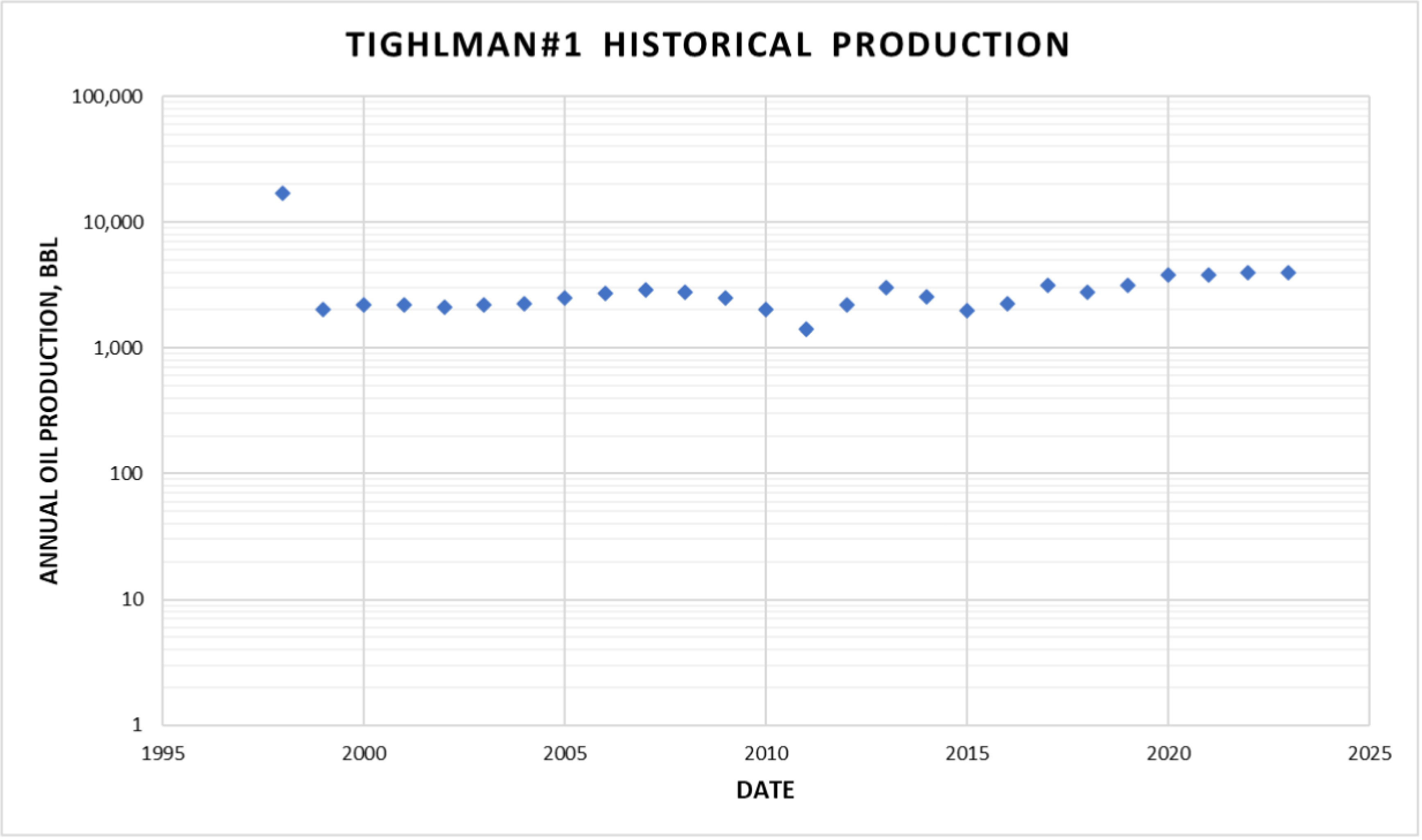
Figure 2: Bullock#7 Historical Production and Decline Model
By applying hydraulic fracturing, the proposed wells could be produced with an initial rate of 2 – 6 times the offset wells' rates. Assuming the proposed well will produce an initial rate of 2 times for the low case, 4 times the mid-case, and 6 times for the high case of the offset wells production. The expected production profile is shown in Figure 1.
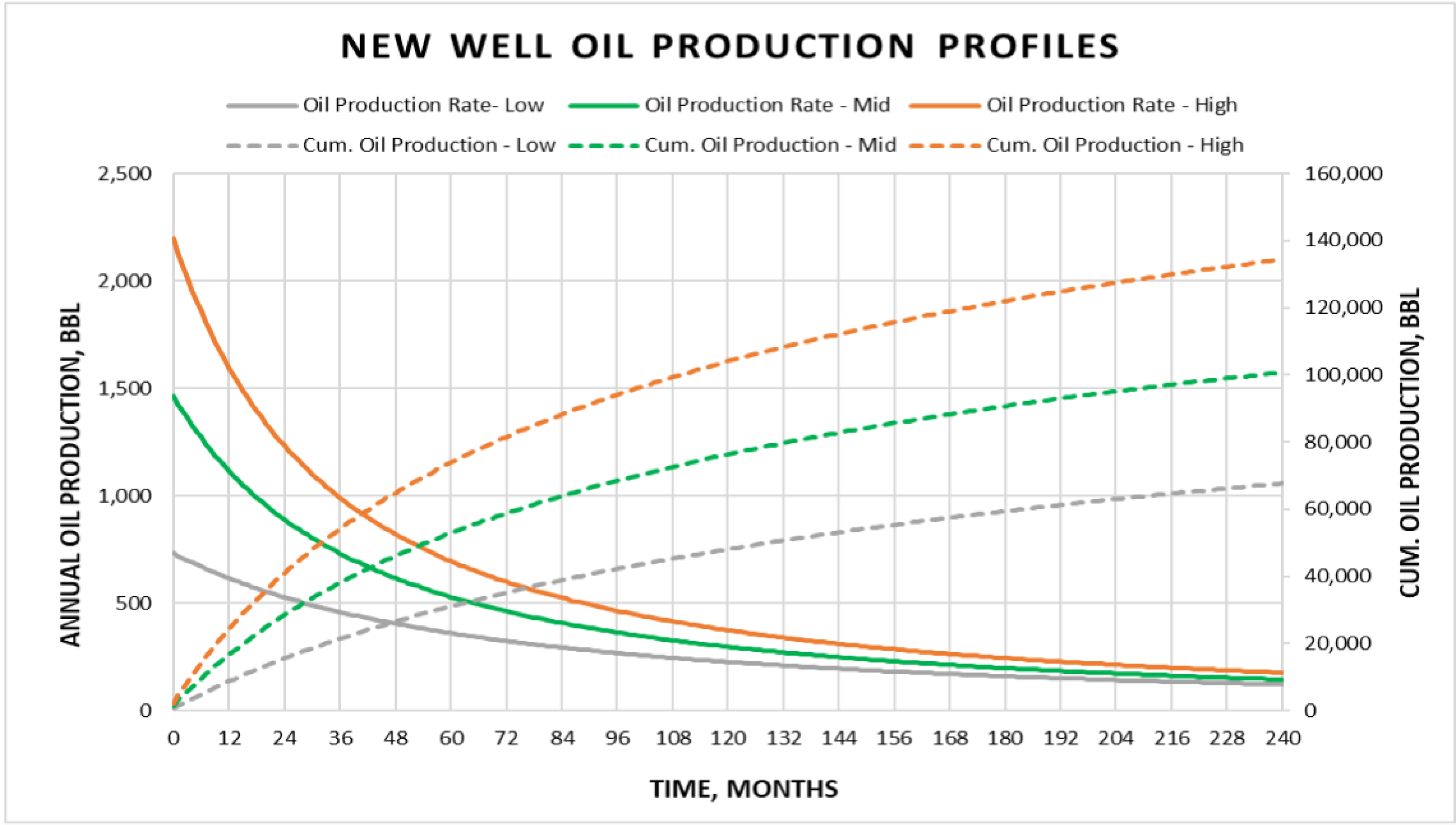
Figure 3: New Well - Oil Production Profiles
The pool production profile is shown in Figure 4. Assuming completing one well per month.
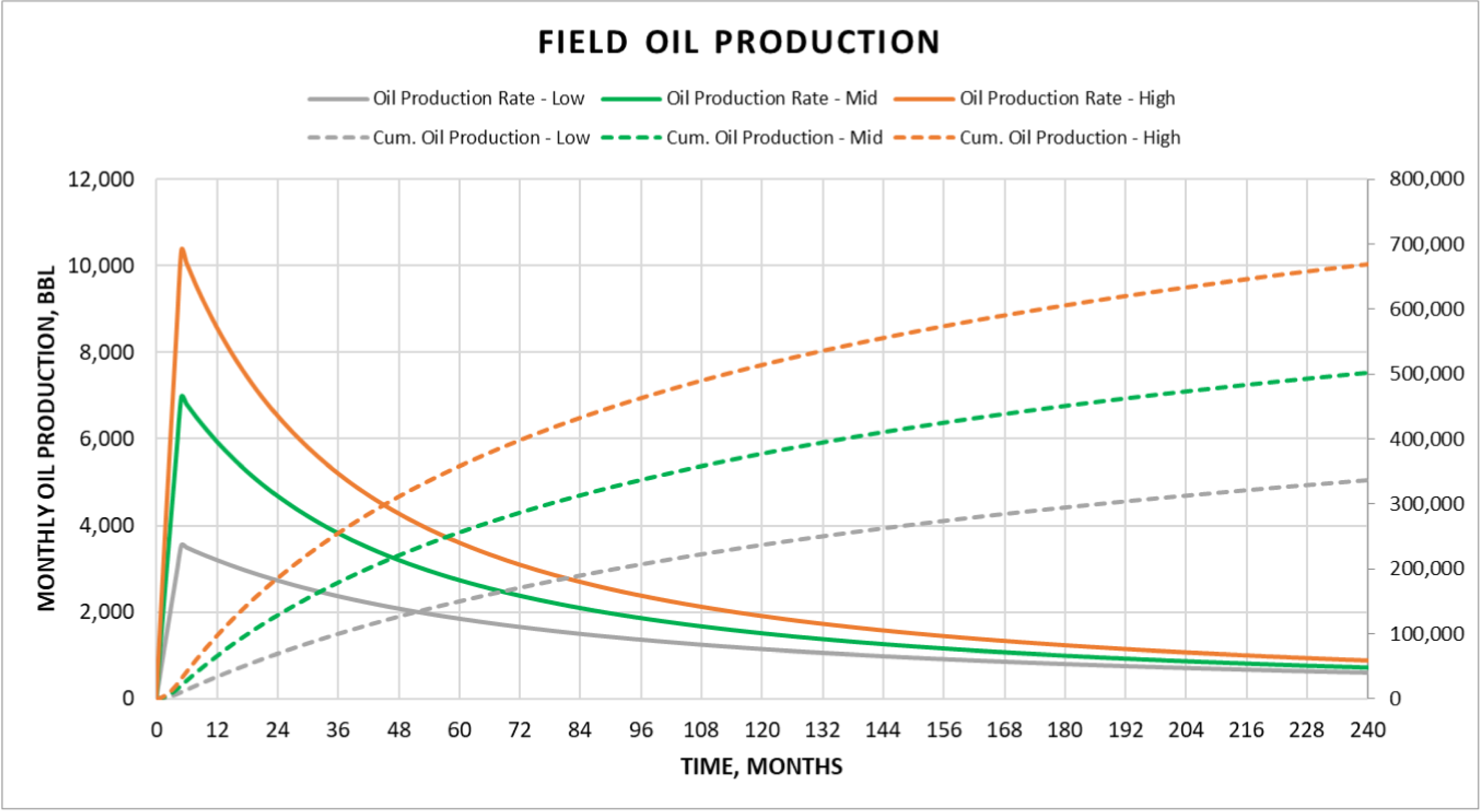
Figure 4: Field Oil Production Profiles
WATERFLOODING DEVELOPMENT

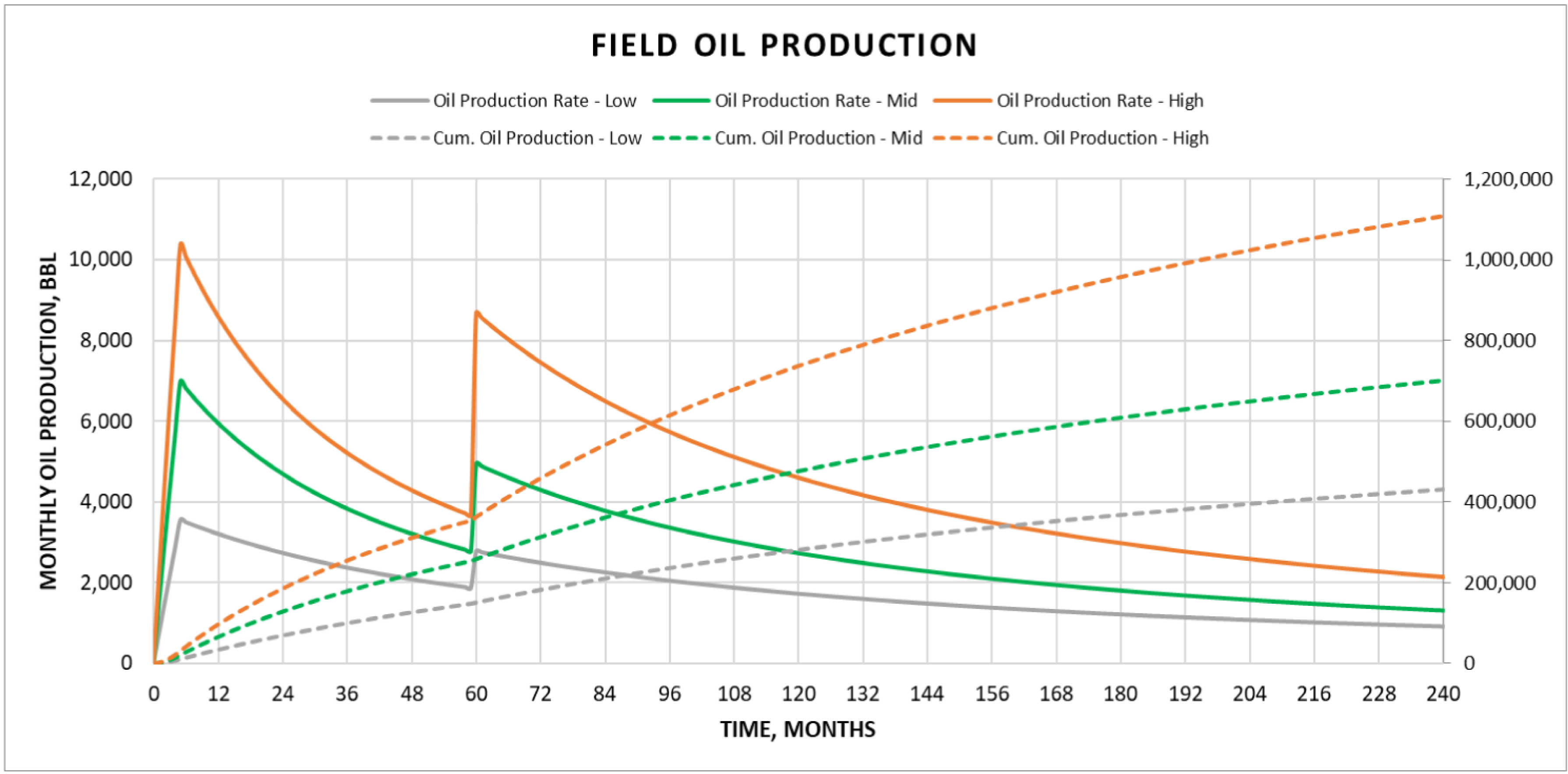
Depletion drive reservoirs are favorable to water flooding as a secondary drive mechanism to maintain the reservoir pressure at higher levels and displace the remaining oil after primary recovery towards the oil producers. Typically, water flooding could recover equal amounts of oil produced during the primary recovery phase, a successful water flooding project could achieve recovery factors of 40%– 60% of the STOIIP. Table 6 summarizes the estimated oil reserves by applying the water flooding option; as tabulated, the recovery factors are more conservative compared to likely recoveries from actual field water flooding projects.
TABLE 6: Summary of Oil Reserves with water flooding application

ECONOMICS
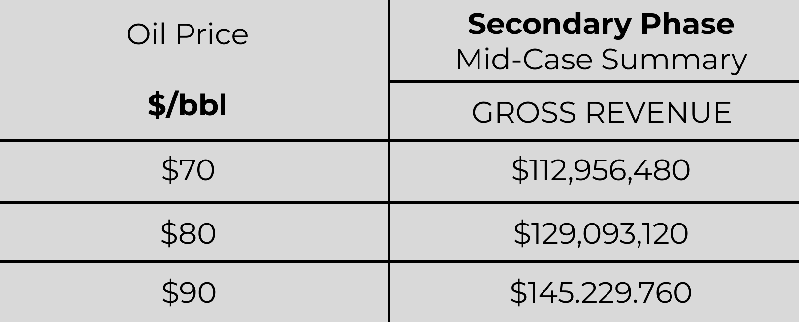
The economics were run using the Mid-Case production forecast scenario plotted at different oil prices ($70, $80, and $90/bbl) along with a summary plot of Gross Revenue for the various production profiles. Table 7 summarizes the economic results of the base case, Table 8 summarizes the water flooding case, the Gross Revenue for the water flooding case is higher than the base case, which confirms that the development plan (depletion then starting waterflooding) is very favorable to the development of the West Asher Pool Extension and justifies the project.

TABLE 7: Summary of economic results for the base case
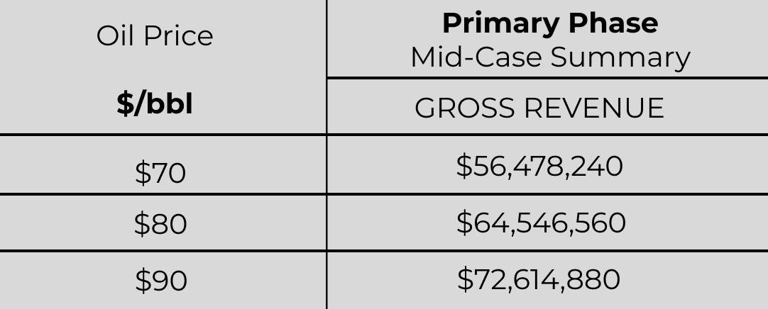
TABLE 8: Summary of economic results for water flooding case
CONCLUSIONS
Developing the West Asher Pool Extension with the initial proposal of drilling 5 wells and applying the waterflooding phase is an attractive project with very promising economic results. The main study findings could be summarized as follows: - The Calvin formation is characterized as a porous, permeable sandstone with sufficient reservoir thickness and continuity throughout the target area containing light oil (42° API). - There are additional three secondary targets include the Hoover Sand, Hogshooter Limestone and Layton Sand, which are consider as upside potential for the project and are not included in the evaluation. - The oil recovery factor for the mid-case is about 15% (~807 Mbbl) for the primary phase and reaches about 30% (~1,614 Mbbl) with the waterflooding application. - These wells have a potential economic life of 50+ years.

Ahmed Ragab, P. E
This document reflects ARM’s informed professional judgment based on accepted standards of professional investigation and, as applicable, the data and information provided by the Client and obtained from other sources (e.g., public domain, published literature), the limited scope of engagement, and the time permitted to conduct the evaluation.
ARM has not independently verified any information provided by, or at the direction of, the Client and has accepted the accuracy and completeness of this data.
Because the reserves data are based on judgments regarding future events, actual results will vary, and the variations may be material. However, any deviations should be consistent with the fact that reserves are categorized according to the probability of their recovery.
In line with those accepted standards, this document does not in any way constitute or make a guarantee or prediction of results, and no warranty is implied or expressed that the actual outcome will conform to the outcomes presented herein
© Magnolaia Ridge Capital LLC - All Rights Reserve 2023
